

By Craig Murray
October 22, 2018 "Information
Clearing House"
-
I expect you are all familiar with the maps
showing the radical shrinking of Palestinian
land over 70 years due to the expansion of
colonial Israeli settlement. Startling and
appalling, yes, but to me they bring back
strong memories of other maps, in a
precisely analogous situation, which goes to
the heart of why Israel is an apartheid
state.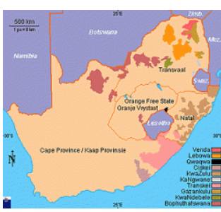
The original apartheid state of South Africa created “homelands”, known colloquially as “bantustans”, and proposed that, as the apotheosis of apartheid, these “homelands” would become independent states and house the majority black population of the country in fenced-off areas which had been too arid, rocky or commercial mineral free to attract significant white settlement over three centuries of theft. South Africa actually did recognise some of these as Independent states, while the rest were supposed to be on a course to recognition.
The maps really do bring out the startling similarity between these two attempts to formalise the dispossession of the original people.
Please register to comment on articles at Information Clearing House. We ask that you post comments, if you have information that confirms or challenges the opinion offered in the article. It is not acceptable to make personal attacks on either the author or other members of the ICH community, doing so will result in cancellation of your posting privileges.
|
Are You Tired Of The Lies And Non-Stop Propaganda? |